


| Height | 4,566 m (14,980 ft) |
| Location | Within Arusha National Park |
| Getting There | An easy 40 - minutes drive from Arusha, approx. 60 km (35 miles) from Kilimanjaro International Airport. |
Mount Meru is an active stratovolcano located 70 km west of Mount Kilimanjaro. At a height of 4,566 m (14,980 ft), it is the fifth highest mountain in Africa and is visible from Mount Kilimanjaro on a clear day.
The mountain is located within Arusha National Park: this prime location gives walkers the opportunity to spot some of the 400 species of birds and wildlife (zebras, elephants, buffalos, giraffes, etc.) that inhabit the area.
Climbing Mount Meru
Mount Meru can be climbed all year round. When deciding a date you may want
to consider average temperatures, humidity, precipitation, cloud cover, wind,
traffic and moon phases. The ascent is quite steep and the route to the summit
passes over streams and through parkland, montane forest, heather and moorland.
The summit is reached by a narrow, barren ridge, which provides stunning
views of the Ash Cone lying several thousand feet below in the crater. There
is one well-established route for the ascent where you will find two huts
for overnight stops, with ample firewood supplied. Arusha National Park regulations
state that climbs of the mountain must take a minimum of 3 days with a recommendation
for 4.
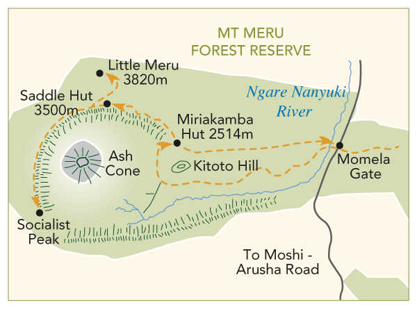
Climbing Route
- Day 1: Momela Gate (1,500m) - Miriakamba Hut (2,514m), 4 hrs hiking
- Day 2: Miriakamba Hut (2,514m) - Saddle Hut (3,570m) - Little Meru (3,801m),
5
hrs hiking - Day 3: Saddle Hut (3,570m) - Socialist Peak (4,566m) - Miriakamba Hut
(2,514m),
10-15 hrs hiking - Day 4: Miriakamba Hut (2,514m) - Momela Gate (1,500m) - Arusha National Park
![]() Acute
mountain sickness
Acute
mountain sickness![]() Pre-departure information
Pre-departure information
Related
Links
Wikipedia
- Mount Meru

 Download
Dik Dik Hotel e-brochure
Download
Dik Dik Hotel e-brochure  Download
Dik Dik Tours e-brochure
Download
Dik Dik Tours e-brochure